
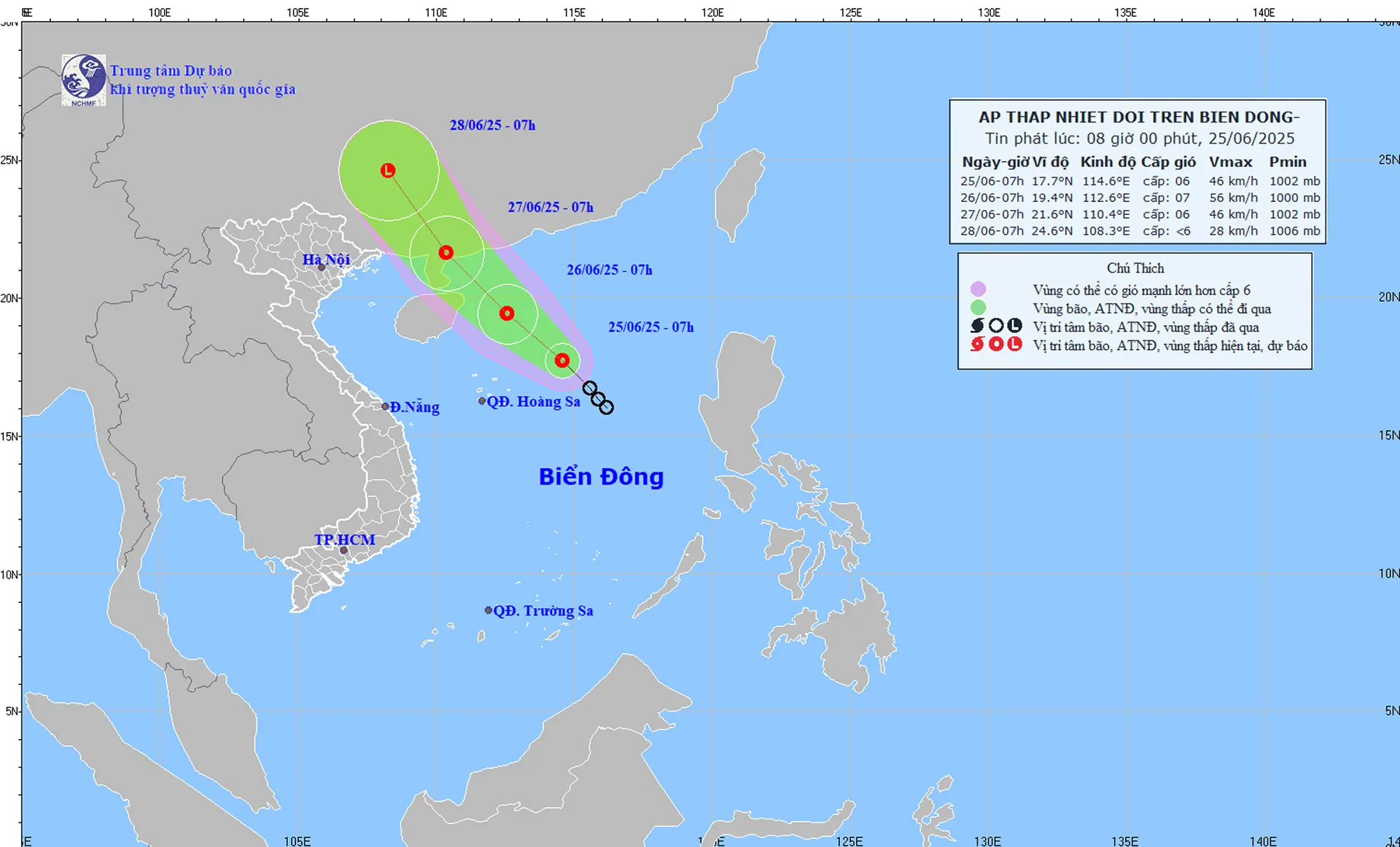
Forecast map of tropical depression trajectory and intensity at 8:00 a.m. on June 25, 2025.
At 7:00 a.m. on June 25, the center of the tropical depression was at about 17.7 degrees north latitude; 114.6 degrees east longitude, about 360 km east-northeast of the Hoang Sa archipelago. The strongest wind near the center of the tropical depression was level 6 (39-49 km/h), gusting to level 8; moving northwest at a speed of 15-20 km/h.
It is forecasted that by 7am on June 26, the tropical depression will move mainly northwest and is likely to strengthen. The center of the tropical depression is at about 19.4 degrees north latitude; 112.6 degrees east longitude, about 180km east of Hainan Island (China). The strongest wind near the center of the tropical depression is level 6 (39-49km/h, gusting to level 9; the affected area includes the northern East Sea including the Hoang Sa archipelago.
It is forecasted that by 7:00 a.m. on June 27, the tropical depression will move mainly northwest and gradually weaken. The center of the tropical depression will be located at about 21.6 degrees north latitude; 110.4 degrees east longitude, about 180km east of the mainland southwest of Guangdong province (China). The strongest wind near the center of the tropical depression will be level 6 (39-49km/h), gusting to level 8; the affected area includes the northwest sea area of the northern East Sea.
From the next 48 to 72 hours, the tropical depression will move northwest at a speed of 15-20km/hour, and its intensity will continue to weaken.
Due to the influence of the tropical depression, the northern East Sea (including the Hoang Sa archipelago) has thunderstorms and strong winds of level 6-7, gusting to level 9, and rough seas. Waves are 2-4m high. Ships operating in the above-mentioned dangerous areas are likely to be affected by thunderstorms, whirlwinds, strong winds, and large waves.
The weather in Kien Giang area in the next 24 to 48 hours will have rain, scattered showers in many places, the rain will be concentrated in the afternoon, evening and night. The wind will be from the west to the southwest at level 3.
Rach Gia - Phu Quoc and Tho Chau sea areas: There is rain, scattered showers and thunderstorms in some places. West to southwest wind level 3-4, sometimes level 5, during thunderstorms, beware of strong gusts of level 6-7. Wave height 0.5-1.5 m. Sea is normal, sometimes slightly rough.
News and photos: THUY TRANG
Source: https://www.baokiengiang.vn/moi-truong/ap-thap-nhiet-doi-tren-bien-dong-khu-vuc-kien-giang-co-mua-dong-nhieu-noi-27115.html


Comment (0)