
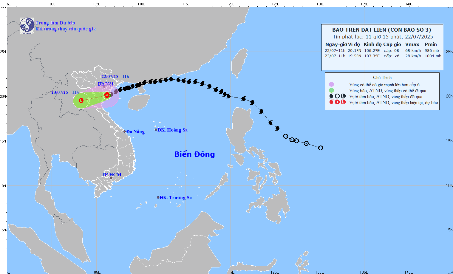
Forecast of storm No. 3's path issued at 11:15 on July 22, 2025.
Due to the influence of storm No. 3, Bach Long Vi special zone has strong winds of level 10, gusting to level 12; Co To special zone has level 9, gusting to level 11; Cua Ong has level 10, gusting to level 12; Tien Yen has level 10, gusting to level 14; Quang Ha has level 9, gusting to level 11; Thai Binh station has level 7, gusting to level 8; Mong Cai has level 7, gusting to level 9; Phu Lien has level 6, gusting to level 8.
The Northern Delta and coastal areas, Thanh Hoa and Nghe An have moderate rain, heavy rain, and very heavy rain in some places (70-150mm, over 200mm in some places).
It is forecasted that by 11am on July 23, the storm will move west-southwest at 10-15km/h and weaken into a tropical depression before continuing to weaken into a low pressure area. The center of the storm is located at 19.5 degrees north latitude, 103.3 degrees east longitude, in the Upper Laos region.
Forecast of storm impact:
Strong winds and big waves at sea
Bac Bo Gulf area (including Bach Long Vi, Co To, Van Don, Cat Hai, Hon Dau and Hon Ngu islands): Wind level 6-7, near the storm center level 8, gust level 10. Wave height 2.0-4.0m, near the storm center 3.0-5.0m. Rough sea.
Rising water, risk of flooding
Coastal area of Hung Yen - Quang Ninh storm surge 0.5-1.0m.
Coastal water levels continue to rise this afternoon.
At Ba Lat (Hung Yen): 2.4-2.6m; Hon Dau (Hai Phong): 3.6–4.1m; Cua Ong (Quang Ninh): 4.4–4.8m; Tra Co: 3.6–4.0m.
Risk of flooding in coastal and estuary areas from noon to afternoon of July 22.
Warning: Coastal land and sea are extremely dangerous and unsafe for ships and coastal structures.
Strong winds on land
Quang Ninh to Nghe An provinces have winds of level 6-7, near the storm center level 8-9, gusting to level 10.
The provinces and cities of Hai Phong, Hung Yen, Bac Ninh, Hanoi, Ninh Binh, and Thanh Hoa have gusts of wind at level 6-8.
Wind warning level 8 can break tree branches, rip off roofs, and damage homes.
Heavy rain on land:
From July 22-23, the southern part of the Northern Delta, Thanh Hoa, and Nghe An will have heavy to very heavy rain, with average rainfall of 100-200mm, and over 300mm in some places.
In other places in the North, Ha Tinh has moderate to heavy rain, rainfall 20-50mm, locally over 100mm.
Risk of heavy rain (over 150mm/3h) causing flash floods, landslides, and inundation of low-lying areas.
NDS
Source: https://baothanhhoa.vn/bao-do-bo-dat-lien-cac-tinh-hung-yen-den-ninh-binh-255701.htm


Comment (0)