(NLDO) - The tropical depression has strengthened into storm No. 10 and is heading towards the sea area from Phu Yen to Ba Ria-Vung Tau.
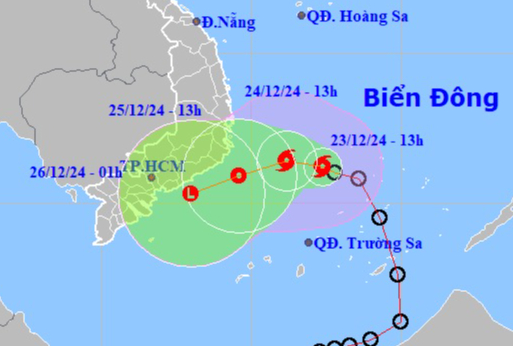
Location and direction of storm No. 10. Source: National Center for Hydro-Meteorological Forecasting
According to the National Center for Hydro-Meteorological Forecasting, this afternoon, December 23, the tropical depression in the sea northwest of Truong Sa archipelago has strengthened into a storm, storm number 10 in 2024, internationally named PABUK.
At 1 p.m., the center of storm No. 10 was at approximately 11.2 degrees North latitude; 112.4 degrees East longitude, in the northwest area of Truong Sa archipelago. The strongest wind near the center of the storm was level 8, gusting to level 10; moving in the West Northwest direction, at a speed of approximately 10 km/hour.
Forecast by 13:00 on December 24, the center of storm No. 10 is at about 11.4 degrees North latitude; 111.2 degrees East longitude; in the sea southwest of the central East Sea, moving in the West Northwest direction, speed about 5-10 km/hour.
Forecast by 1:00 p.m. on December 25, the center of storm No. 10 is at about 10.9 degrees North latitude; 109.6 degrees East longitude; on the sea from Phu Yen to Ba Ria-Vung Tau, moving in the West-Southwest direction, about 5-10 km/hour and gradually weakening into a tropical depression.
Due to the impact of storm No. 10, on the day and night of December 23, the North and Central East Sea (including the waters of Hoang Sa archipelago), the sea north of the South East Sea (including the waters north of Truong Sa archipelago), and the sea from Quang Tri to Binh Thuan will have showers and thunderstorms. During thunderstorms, there is a possibility of tornadoes and strong gusts of wind.
On the day and night of December 24, in the North East Sea (including the waters of Hoang Sa archipelago), the Northeast wind is strong at level 7, gusting to level 8-9. The sea is rough; waves are 4-6 m high.
The sea area from Phu Yen to Ba Ria Vung Tau, the sea area southwest of the Central East Sea area and northwest of the South East Sea area (including the sea area northwest of Truong Sa archipelago) has strong winds of level 6-7, gusting to level 9. Rough seas; waves 3-6 m high.
Other areas of the Central East Sea have strong northeast winds of level 6, gusting to level 7-8. Rough seas. Waves 3-5 m high.
The sea from Quang Tri to Khanh Hoa has strong northeast wind at level 6, in the South at times level 7, gusting to level 8-9. Rough sea; waves 3-6 m high.
Ships operating in the above mentioned dangerous areas are likely to be affected by storms, whirlwinds, strong winds and large waves.
Source: https://nld.com.vn/bao-so-10-huong-vao-vung-bien-phu-yen-den-ba-ria-vung-tau-196241223143319195.htm








































Comment (0)