On the evening of July 21, in Hanoi , Director of the National Center for Hydro-Meteorological Forecasting, Mr. Mai Van Khiem chaired a press conference on the situation of storm No. 3 (Wipha).

Mr. Mai Van Khiem said that after passing the northern part of Leizhou Peninsula (China) on the morning of July 21, storm No. 3 (Wipha) entered the Gulf of Tonkin at level 9. By noon and afternoon of July 21, the storm had strengthened again to level 10.
By 5:00 p.m. on July 21, the storm center had moved to coordinates of about 20.9 degrees North latitude - 108.7 degrees East longitude, only 100km from Quang Ninh, 220km from Hai Phong , 240km from Hung Yen, and 270km from Ninh Binh. The area near the storm center had strong winds of level 10, gusting to level 12, moving in a West-Southwest direction at a speed of 15km/hour.
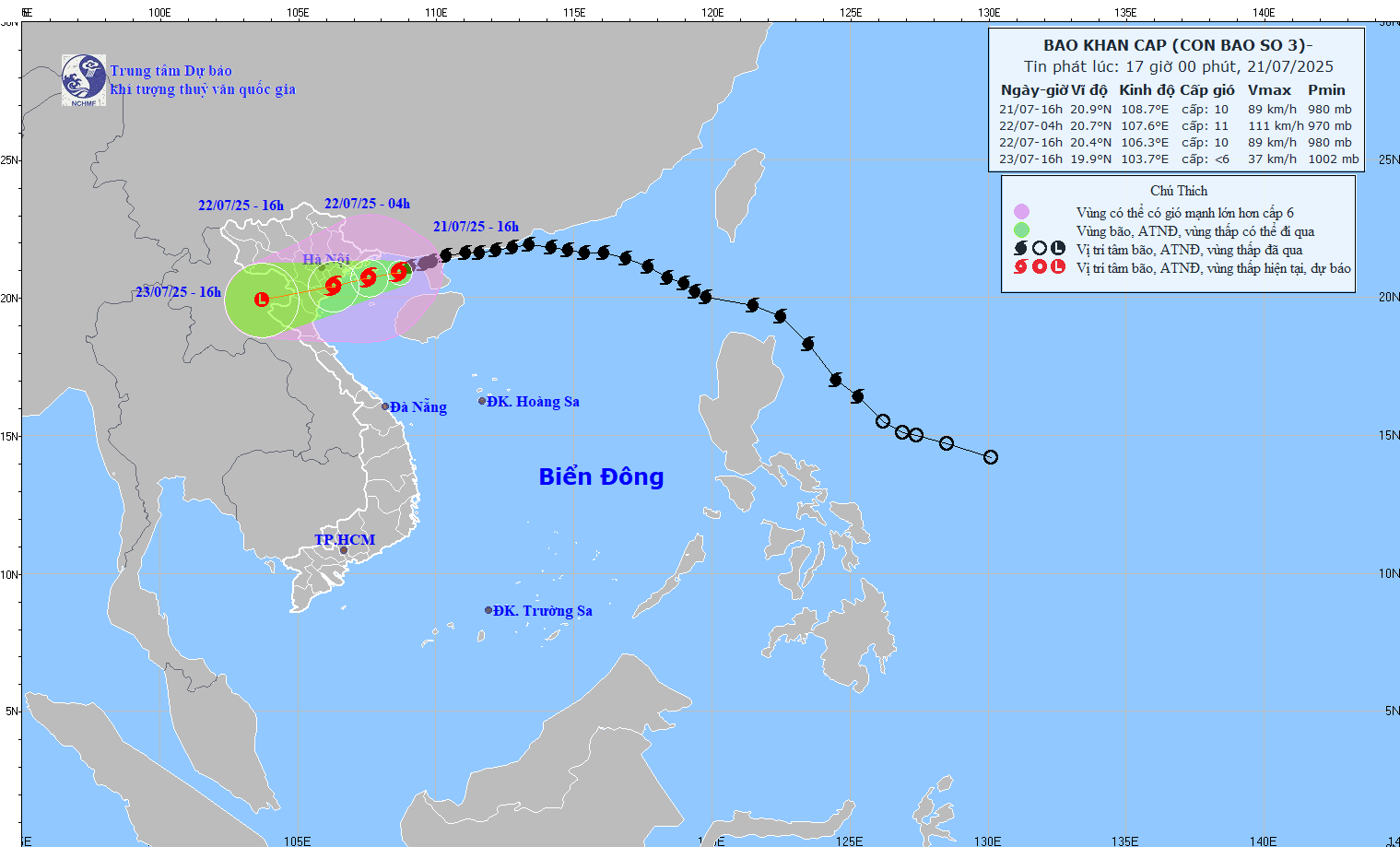
Mr. Khiem said that in Quang Ninh province, there were gusts of level 7 in Uong Bi, Mong Cai; level 6 in Bai Chay and Co To. In Hai Phong city, Bach Long Vi island had winds of level 8, gusts of level 10; Hon Dau island had winds of level 4, gusts of level 5. Hung Yen, Thai Binh , Ninh Binh and Thanh Hoa areas are having winds from level 3 to level 6, many places have 40-50mm of rain, continuing to have moderate to heavy rain.

The Director of the National Center for Hydro-Meteorological Forecasting said that the eye of the storm will make landfall in the provinces from Hai Phong to North Thanh Hoa from noon to afternoon tomorrow, July 22. In coastal areas, very dangerous strong winds are forecast:
- Hai Phong, Hung Yen (former Thai Binh): level 9-10, jerk 13-14
- Ninh Binh: level 8-9, shock 13
- North Thanh Hoa: level 7-8, jerk 8-9
- Hanoi: noon, tomorrow afternoon wind level 5-6, gust 7-8
Widespread heavy rain
From tonight to the morning of July 23, the key areas of Hung Yen, Ninh Binh, South Phu Tho, Thanh Hoa, Nghe An will have widespread rain of 200-350mm, some places over 600mm. The remaining areas of the North and Ha Tinh will have rain of 100-200mm, some places over 300mm. There is a risk of flash floods and landslides in mountainous provinces, widespread flooding in the plains.
The National Center for Hydro-Meteorological Forecasting has warned of heavy rain, strong winds, high tides and widespread flash floods. Many low-lying, coastal and mountainous areas face a high risk of damage.
High tide in storm
On the afternoon of July 22, many localities may experience record high tides:
- Hon Dau (Hai Phong): 3.9-4.3m
- Cua Ong (Quang Ninh): 4.6-5m
- Tra Co (Quang Ninh): 3.6-4m
- Ba Lat (Hung Yen): 2.4-2.6m
Places that need emergency response
According to the representative of the National Center for Hydro-Meteorological Forecasting, the areas that need to immediately respond to strong winds, big waves, and rising water threatening the coast are: Bai Chay, Ha Tu, Mong Cai, Co To (Quang Ninh); Bach Long Vi, Cat Hai, Do Son (Hai Phong); 15 coastal communes of Ninh Binh; communes on the water's edge of Thanh Hoa; Thai Thuy and Tien Hai communes (Hung Yen).
Flash floods and landslides are especially dangerous in 24 highland communes of Thanh Hoa, 50 communes of Nghe An (Tuong Duong, Que Phong, Con Cuong...) and mountainous communes of Son La.
Don't be subjective.
Mr. Khiem emphasized that people need to continuously monitor warnings from official stations, reinforce their homes, and stock up on necessities. According to him, people should not go out when there are strong winds or heavy rains, and stay away from areas prone to landslides and deep flooding.
The Director of the National Center for Hydro-Meteorological Forecasting also suggested: At this time, whether in the North or the Central region, fishermen should absolutely not go out to sea, need to anchor safely, withdraw people from boats and watchtowers. Localities must prepare evacuation plans in the worst case scenario.
Source: https://www.sggp.org.vn/bao-se-do-bo-hai-phong-thanh-hoa-post804769.html































Comment (0)