
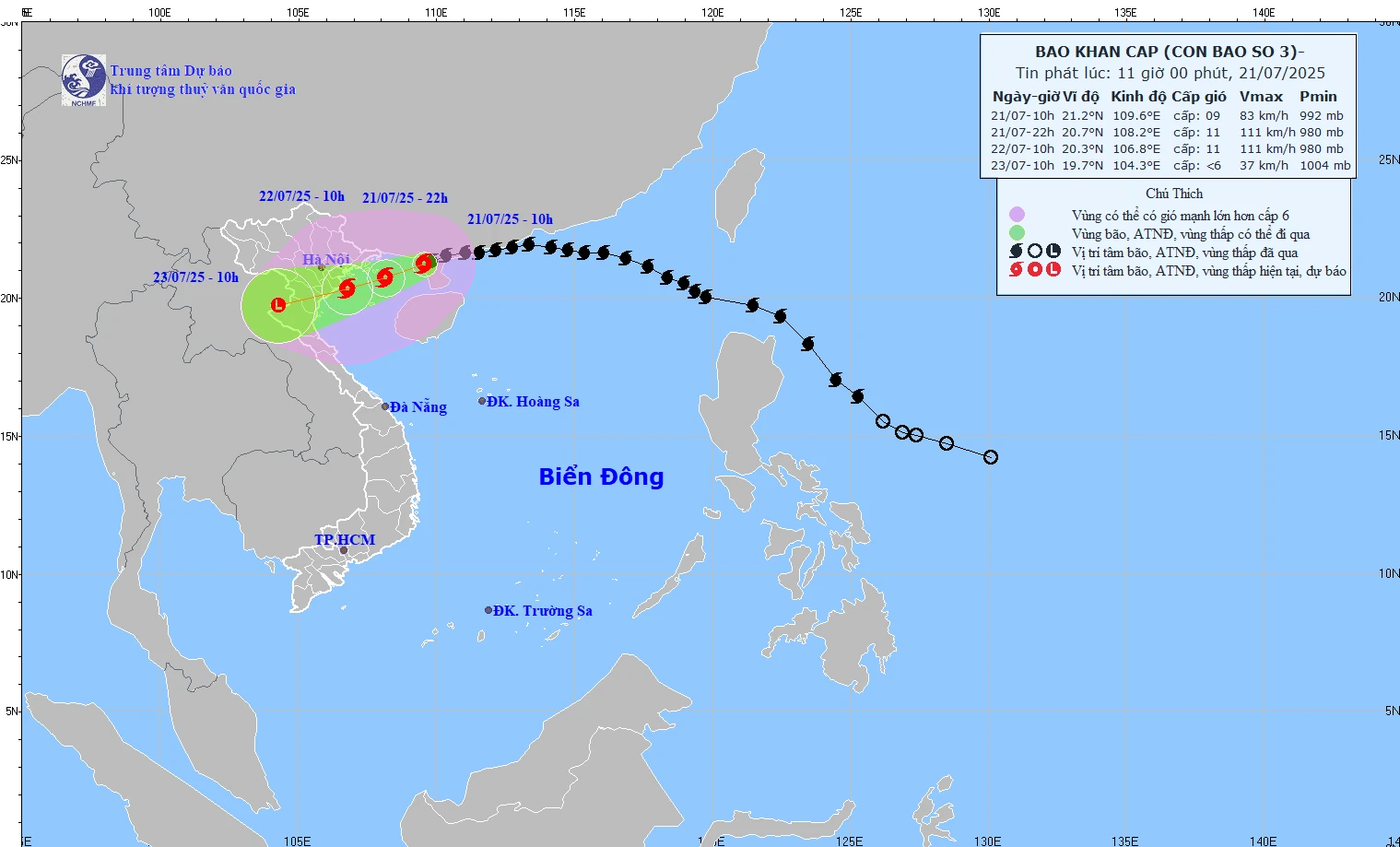
Forecast path of storm No. 3 at 11:00 on July 21, 2025.
At 10:00 a.m., the storm center was located at about 21.2 degrees North latitude; 109.6 degrees East longitude, about 190km from Quang Ninh, 310km from Hai Phong ; the strongest wind near the storm center was level 9 (75-88km/h), gusting to level 11; moving in the West Southwest direction at a speed of 10-15km/h.
Forecast, 10pm on July 21, the storm center will be at about 20.7 degrees North latitude; 108.2 degrees East longitude (Northern Gulf of Tonkin). Intensity level 10-11, gust level 14.
At 10:00 a.m. on July 22, the storm center was at about 20.3 degrees North latitude; 106.8 degrees East longitude (Hai Phong - Thanh Hoa sea area). Intensity level 10-11, gust level 14.
At 10:00 a.m. on July 23, the storm center was at about 19.7 degrees North latitude; 104.3 degrees East longitude (on the mainland of Upper Laos), weakening into a low pressure area.
In the Northwestern sea of the North East Sea, there will be winds of level 7-8, gusting to level 10; waves 3-5m high; rough seas.
Northern Bac Bo Gulf (Bach Long Vi, Co To, Van Don, Cat Hai, Hon Dau) has wind level 6-7, then increasing to level 8-9, near the storm center level 10-11, gust level 14; waves 4-6m; rough seas.
South of Bac Bo Gulf (Hon Ngu), wind gradually increases to level 6-7, near the storm center level 8-9, gusting to level 11; waves 2-4m high; very rough seas.
From July 21-23, the Northeast, the Northern Delta, Thanh Hoa, and Nghe An regions will have rainfall of 200-350mm, with some places receiving over 600mm. Other areas in the North and Ha Tinh will have rainfall of 100-200mm, with some places receiving over 300mm. There is a risk of extremely heavy rain (>150mm/3 hours), flash floods, landslides, and flooding in low-lying areas.
The disaster risk level in the Gulf of Tonkin, coastal and mainland areas from Quang Ninh to Nghe An is level 3.
NDS
Source: https://baothanhhoa.vn/bao-so-3-da-di-vao-vinh-bac-bo-cach-quang-ninh-190km-255548.htm


Comment (0)