
According to the Vinh Long Province Hydrometeorological Station, at 7:00 a.m. on August 8, the center of the tropical depression was at about 19.0 degrees North latitude; 118.2 degrees East longitude, in the eastern sea area of the North East Sea. The strongest wind near the center of the tropical depression was level 6 (39-49 km/h), gusting to level 8; moving in the West Northwest direction at a speed of about 10-15 km/h.
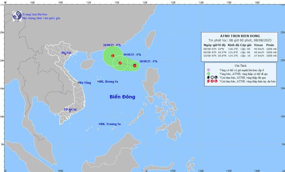 |
| Forecast map of tropical depression trajectory and intensity at 8:00 a.m. on August 8, 2025. |
Forecast of tropical depression (in the next 24-48 hours), at sea: The eastern sea area of the North East Sea has thunderstorms and strong winds of level 6, gusts of level 8, rough seas. Waves are 2-3m high. Ships operating in the above-mentioned dangerous areas are likely to be affected by thunderstorms, whirlwinds, strong winds, and large waves.
Weather in Vinh Long province in the next 24 hours, cloudy, sunny during the day, rain in the afternoon, moderate rain and thunderstorms in the province, some places. Rainy areas are mainly concentrated in the forecast locations: Cai Von, Long Chau, Tra On, Cai Nhum, Tra Vinh , Tra Cu, Tieu Can, Cang Long, Cho Lach. Generally no rain at night. During thunderstorms, beware of strong gusts of wind and tornadoes. Southwest wind level 2, coastal winds sometimes level 3.
From August 9-10, rain increased in area and volume, with widespread rain across the province, concentrated in the afternoon and evening.
Weather in Vinh Long sea area in the next 24 hours, cloudy, with showers and thunderstorms in some places in the afternoon. Southwest wind level 3-4, waves 0.5-1m high. Sea is normal.
Ships operating at sea regularly monitor and update the location and path of tropical depressions to have direction of movement and find safe shelter.
News and photos: THAO LY
Photo: Direction of movement of tropical depression.
Source: https://baovinhlong.com.vn/thoi-su/202508/anh-huong-ap-thap-nhiet-doi-tu-9-108-vinh-long-mua-gia-tang-ve-dien-va-luong-2f41247/


Comment (0)