
Risk of flash floods on small rivers and streams, landslides on steep slopes in many communes/wards: Bum Nua, Bum To, Hua Bum, Muong Te, Pa Tan, Pa U, Ta Tong, Thu Lum (Lai Chau province); Chau Que, Chieng Ken, Gia Phu, Hop Thanh, Khanh Yen, Lung Phinh, Cam Duong, Si Ma Cai, Tang Loong (Lao Cai province); Ban May, Hoang Su Phi, Lao Chai, Minh Tan, Nam Dan, Ha Giang 2, Pho Bang, Po Ly Ngai, Thang Mo, Thang Tin, Thanh Thuy, Trung Thinh, Tung Ba, Xin Man, Yen Minh (Tuyen Quang province).
Warning level of natural disaster risk due to flash floods, landslides, land subsidence due to heavy rain or level 1 flow.
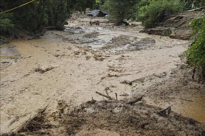
Heavy rains are likely to cause flooding in low-lying areas, urban and industrial areas; flash floods on small rivers and streams, landslides on steep slopes (information warning of areas at risk of flash floods and landslides is provided on the website of the Department of Hydrometeorology at: https://luquetsatlo.nchmf.gov.vn).
Flash floods and landslides can have very negative impacts on the environment, threaten people's lives; cause local traffic congestion, affect the movement of vehicles; destroy civil and economic works, causing damage to production and socio-economic activities.
The hydrometeorological agency reminds people to regularly monitor forecast and warning information on the website of the National Center for Hydrometeorological Forecasting at nchmf.gov.vn, and provincial, municipal and regional hydrometeorological stations. At the same time, regularly update the latest hydrometeorological forecast information on central and local mass media to proactively respond. At the same time, it is recommended that local authorities in affected areas pay attention to reviewing bottlenecks and vulnerable locations in the area to take preventive measures.
According to the guidance of the Department of Dyke Management and Natural Disaster Prevention and Control (Ministry of Agriculture and Environment), affected areas closely monitor developments of heavy rain, floods, flash floods, landslides, in order to promptly and fully inform authorities at all levels and people to proactively prevent, respond, and minimize damage.
Localities deploy shock forces to inspect and review residential areas along rivers, streams, and low-lying areas to proactively organize the relocation and evacuation of people in areas at high risk of deep flooding, flash floods, and landslides; organize forces ready to control and direct traffic, and place warning signs, especially through culverts, spillways, and areas with deep flooding and fast-flowing water; proactively arrange forces, materials, and means to overcome incidents, ensuring smooth traffic on main traffic routes when heavy rain occurs...
From 11am to 2pm on August 6, Lai Chau, Lao Cai and Tuyen Quang provinces had rain, some places had moderate to heavy rain such as: Nang Don (Tuyen Quang) 56 mm; Nam Tha (Lao Cai) 48 mm; Nam Ban (Lai Chau) 44.4 mm...
Soil moisture models show that some areas in the above provinces are close to saturation (over 85%) or have reached saturation.
Source: https://www.sggp.org.vn/mua-lon-nguy-co-lu-quet-sat-lo-dat-o-vung-nui-phia-bac-post807149.html


![[Photo] Discover the "wonder" under the sea of Gia Lai](https://vphoto.vietnam.vn/thumb/1200x675/vietnam/resource/IMAGE/2025/8/6/befd4a58bb1245419e86ebe353525f97)

![[Photo] Nghe An: Provincial Road 543D seriously eroded due to floods](https://vphoto.vietnam.vn/thumb/1200x675/vietnam/resource/IMAGE/2025/8/5/5759d3837c26428799f6d929fa274493)


Comment (0)