
There are currently three storms active in the Northwest Pacific region, including: storm No. 4 Comay (Co May) at longitude 118, which has almost no impact on the mainland and coastal areas of our country; storm Francisco at longitude 128; and storm Krosa at longitude 140 degrees East, which has just strengthened from a tropical depression at 10:30 on July 24.
Storm Krosa is forecast to move north, not into the East Sea.

Since the beginning of the year, the East Sea has welcomed 4 storms: Storm No. 1 Witip, Storm No. 2 Danas, Storm No. 3 Wipha has just dissipated after making landfall in our country, and Storm No. 4 Co May is active in the eastern sea of the North East Sea with an intensity of level 9-10, gusting to level 12. The storm moves in a southeast direction at a speed of about 10km/h.
In the next 24 hours, storm No. 4 will continue to "swarm" the eastern sea area of the North East Sea, with unchanged intensity, then enter the northern area of Luzon Island (Philippines) and gradually weaken.
According to the meteorological agency, from August to October 2025, ENSO is likely to remain neutral with a probability of 70-90%. Storms and tropical depressions operating in the East Sea and affecting our country may be approximately the average of many years.
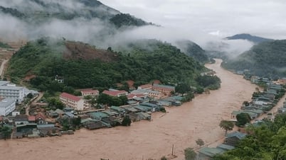
Also in these 3 months, moderate and heavy rains are likely to occur across the country, concentrated in the North in August and September; the Central region in September and October. Total rainfall across the country is equivalent to the average of many years in the same period, in which, in September and October, the northeastern coast of the North, Thanh Hoa to Quang Ngai tends to be 10-30% higher.
In addition, heat waves also occur in the North, the area from Thanh Hoa to Hue and the South Central Coast until August. From September, the heat waves gradually decrease. The number of hot days is likely to be lower than the average of many years.
The heat will gradually decrease, cold air will tend to become stronger from around October.
Storms, tropical depressions and southwest monsoons cause strong winds and large waves that affect shipping activities. Heat waves, heavy rains, thunderstorms, tornadoes and lightning can negatively affect production activities and public health.
Source: https://baolaocai.vn/ba-con-bao-cung-hoat-dong-tren-khu-vuc-tay-bac-thai-binh-duong-post649610.html


Comment (0)